More Information ↓  
 
 
  Printer Friendly Map | Walking Directions  


Distance: 6.5 km
Time to complete: 1 hour 45 minutes

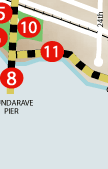
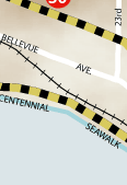
Dundarave was named after Dundarave castle in Loch Fine Scotland. Originally, the area was a notable secluded holiday spot for vacationing Vancouverites; however, in 1914 a pier was built at 25th Street and the area flourished. The very first West Vancouver swimming club was created in Dundarave and it also held the very first regatta. Social life revolved around the local Clachan restaurant and over time it expanded to include a hotel. Today, the refurbished Clachan has become the Beach House Restaurant and continues to be a community gathering place for local residents. The area adjacent to the restaurant has been developed into a park and anchors the western edge of the Centennial Seawalk.

 
1.  Dundarave
2.   Sagers' Building
3.  Gas Station
4.  Dental Building
5.  Dundarave Park
6.  Western Catalpa
7.  Fortune Cup Inn (Lost site)
8.  Dundarave Pier
9.  Point Atkinson Lighthouse
10.  Beach House Restaurant
11.  Centennial Seawalk
12.  Villa Maris
13.  Navvy Jack Point
14.  Weston Park
15.  Pacific Great Eastern Railway Company
16.  Shoreland Apartments
17.  Crescent Apartments
18.  Lions Gate Bridge
19.  Monkey Puzzle Tree
20.  California Redwood
21.  West Vancouver Memorial Library
22.  Memorial Park
23.  West Vancouver Lawn Bowling Club
24.  Atlas Blue Cedar
25.  First Church of Christ, Science
26.  West Vancouver United Church
27.  Civic Site
28.  St. Stephen's Anglican Church
29.  California Laurel
30.  Hodgson House (Lost Site)
31.  Mulberry Tree
32.  Irwin Park Elementary
33.  Archibald House
34.  Maple Leaf Garden Centre
35.  Harrison House (1923)
36.  Harrison House (1913)
37.  Shaw House
38.  Bell House
39.  Robson House
40.  St. Anthony's Parish
41.  Young House